
I just returned from visiting Red Lodge, MT, and driving the Beartooth Highway to ski at Beartooth Basin. I say this because I live in the San Juan Mountains and the Tetons and have visited mountains worldwide; this highway is one of the most gorgeous drives I’ve ever done.
I’d love to share my experience of the drive and my experience skiing at the Beartooth Basin Summer Ski Area.

Mountain Goats forage along a mountain peak across from the Beartooth Pass in Montana.
Table of Contents
Discover the Thrilling Beartooth Highway
Experience the breathtaking adventure of the Beartooth Highway, a legendary stretch of U.S. Route 212 that will take you on a thrilling journey between Red Lodge and Cooke City, Montana. This remarkable highway, nestled along the majestic Montana-Wyoming border at the 45th parallel, unveils a mesmerizing display of nature’s wonders as it winds through steep zigzags and switchbacks, ultimately reaching the awe-inspiring Beartooth Pass, standing tall at an impressive 10,947 feet (3,337 meters).

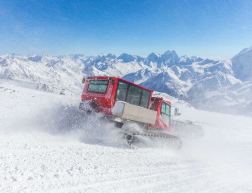
snow plow at top of the world beartooth highway
Key Statistics
- The highway covers 68.7 miles (110.6 km) with a 5,000 ft. elevation gain.
- Beartooth Pass in Wyoming is 10,947 feet (3,337 m) above sea level [1].
- The Beartooth Highway is typically open for approximately five months, from mid-May to mid-October [1].
- Due to its high elevation and challenging terrain, the highway features steep grades, hairpin turns, and narrow lanes [2].
- It is recognized as an All-American Scenic Byway, highlighting its exceptional beauty and significance [2].

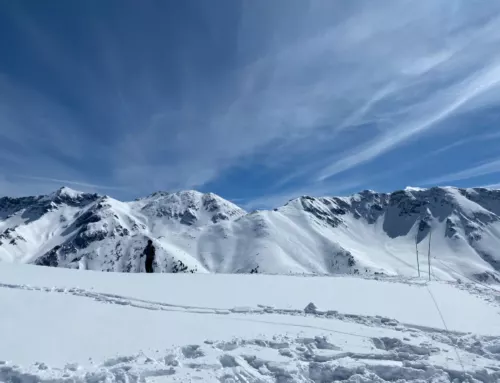
Geography and Scenic Beauty
- The Beartooth Highway passes through the Absaroka-Beartooth Wilderness, offering stunning views of lakes and surrounded by national forests including Custer, Shoshone, and Gallatin [1].
- The highway traverses the Beartooth Plateau, which features ancient rocks and the majestic Beartooth Mountains [3].
- The road ascends steeply from Red Lodge, providing panoramic views from the Rock Creek Vista Overlook [3].
- Along the route are various attractions and points of interest, including Silver Gate, Cooke City, Bannock Trailhead, alpine lakes, and waterfalls [2].
- Rock Creek Vista Overlook: Located 21 miles from Red Lodge with an elevation of 9,190 feet, this overlook offers breathtaking views of Rock Creek Canyon and the Hellroaring Plateau.
- There are 20 peaks over 12,000 feet in elevation

History and Significance
- The Beartooth Highway holds historical significance, with General Philip Sheridan crossing it in 1872 [1].
- In August 1872, Civil War General Philip Sheridan and his courageous band of 120 men embarked on an unforgettable expedition, crossing the pass while returning from a captivating Yellowstone National Park inspection tour. Inspired by the wisdom of a seasoned hunter named Shuki Greer, who possessed intimate knowledge of the Beartooth Mountains, Sheridan’s route formed the basis for the road that would eventually grace the landscape.
- Built between 1932 and 1936, the highway was a transportation route for supplying mining camps and military posts [2].
- In 2005, the highway underwent extensive reconstruction after mudslides and rockslides damaged portions of it [1].

Driving and Safety
- The Beartooth Highway can be challenging due to its steep inclines, sharp curves, and potential for adverse weather conditions. It is closed during winter due to heavy snow and high winds [5]. It can also close without notice in the summer.
- Give yourself 2-4 hours to drive it. Check with the Red Lodge Chamber of Commerce or the Beartooth Ranger District for potential road closures.
- It is essential to be prepared for changing weather conditions and exercise caution while driving, especially during inclement weather. Travelers should also check for road closures and conditions before starting the journey. Be prepared for thunderstorms, rainstorms, and fog. Drive with your headlights on.

Day Trip Itinerary: Red Lodge to Cooke City or Yellowstone
Start in Red Lodge, Montana: Beartooth Pass Montana
-
- Explore the charming downtown and its shops, restaurants, and galleries.
- We loved Cattail Bakery and Prerogative Kitchen
- We stayed at this Airbnb.
- There are plenty of activities for the outdoor enthusiast.
- Explore the charming downtown and its shops, restaurants, and galleries.
Take a Break at Vista Point Rest Area
-
- Located 21 miles from Red Lodge at 9,190 feet.
- Enjoy breathtaking views of mountains, valleys, and a waterfall.
- Learn about the area’s natural history and highway construction.
- Facilities include restrooms, picnic tables, and scenic overlooks.
Cross the 45th Parallel
-
- Experience the awe-inspiring moment halfway between the North Pole and the equator.
- Enjoy the panoramic view of Montana’s alpine country.
- Witness the transition to a barren landscape dominated by alpine tundra. Goodbye, trees!

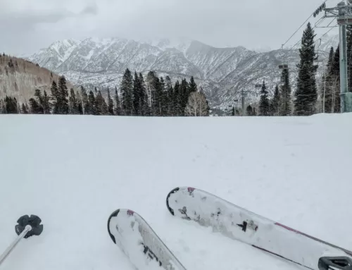
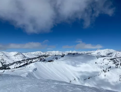
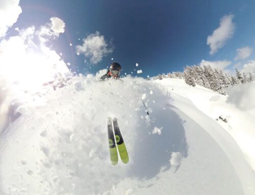
Watch Skiers at the Beartooth Basin Summer Ski Area
-
- Visit the ski area near the summit of Beartooth Pass.
- Witness impressive skiing skills in unique terrain.
- Two high-speed Poma lifts facilitate access for skiers.

See the Bear’s Tooth
-
- Marvel at the striking Bear’s Tooth formation along the Beartooth Highway.
- Enjoy viewpoints near Beartooth Pass and Island Lake for the best views.
- Appreciate the surrounding landscape with alpine lakes, waterfalls, and meadows.

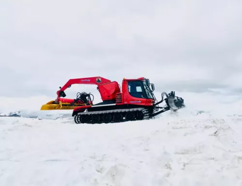
Snow plow at Top of World Store
Shop at The Top of The World Store
-
- Visit the charming store at an elevation of 9,396 feet.
- Experience a unique oasis in the wilderness.
- Take a break, rest, and explore the store’s offerings.

Explore the Alpine Lake
-
- After visiting The Top of The World Store, drive along the Beartooth Highway.
- Look out for a stunning alpine lake just past The Top of The World Store.
- Take a break and immerse yourself in the serene beauty of the lake and its surroundings.

Cooke City Overnight Stay
-
- After enjoying the alpine lake, head towards Cooke City.
- Consider staying overnight in Cooke City, a charming mountain town along the Beartooth Highway.
- Relax and soak in the cozy atmosphere of Cooke City before continuing your journey.
Venture into Yellowstone
-
- Alternatively, you can use Cooke City as a base to explore Yellowstone National Park.
- Head into Yellowstone from the Northeast Entrance, conveniently located near Cooke City.

FAQs About Beartooth Highway Yellowstone
How can I access the Beartooth Highway?
Visitors have several options to access the Beartooth Highway, including driving, flying, and obtaining necessary permits. Here’s what you need to know:
Driving Directions
The Beartooth Highway begins in Red Lodge, Montana, about 60 miles southwest of Billings. From there, the highway heads south through the Beartooth Mountains before ending at the northeast entrance of Yellowstone National Park.
Nearest Airports to Beartooth Wyoming:
- Billings Logan International Airport is the closest major airport to Red Lodge, about 60 miles away. Car rentals are available at the airport.
- Bozeman Yellowstone International Airport: This airport is 130 miles northwest of Red Lodge. Car rentals are available at the airport.

Are there any hiking trails accessible from the Beartooth Highway?
|
Trail |
Description |
|
Island Lake and Night Lake Trail |
This well-traveled trail starts at the Island Park Campground and takes you along Island Lake, Night Lake, and other smaller lakes. It offers spectacular views and is considered a fantastic hike with easy terrain. |
|
Gardner Lake Trail |
This high-altitude trail offers stunning views. It begins at the Gardner Lake Trailhead and takes you down a gradual ridge into the valley of Twin Lakes, passing through informal campsites. The endpoint is the rocky split between the lakes. |
|
Beartooth Pass Trail |
Located near Gardner Lake Pullout, this trail provides access to the Beartooth Loop Trail and offers panoramic views from the pass. It is known for its stunning vistas and is a popular spot for picnics. |
|
Beartooth High Lakes Loop |
Situated on the Wyoming side of Beartooth Pass, this 14-mile loop trail starts at either the Island Lake Trailhead or the Beartooth Lake Trailhead. It offers breathtaking views of Island and Night Lakes, Lonesome Mountain, and other impressive rock formations. Hikers can choose different directions at the loop junction, leading to Claw and Native Lakes or Beauty Lake. |
Are there any waterfalls along the Beartooth Highway in Montana?
|
Waterfall |
Distance from Yellowstone Park |
Distance from Red Lodge, MT |
Distance from Chief Joseph Highway |
|
Beartooth Falls |
26.7 mi |
41.3 mi |
8.9 mi |
|
Lake Creek Falls |
18.8 mi |
48.2 mi |
1.2 mi |
|
Crazy Creek Falls |
14.9 mi |
53.1 mi |
1.85 mi |

Road Maintenance
The Beartooth Highway, despite its designation as a U.S. highway and its connection to Wyoming Highway 296, is not maintained by the Wyoming Department of Transportation or the U.S. Forest Service. Instead, it falls under the care of the National Park Service, a testament to its unique character. While not officially part of the park, like the Foothills Parkway or Skyline Drive, or an individual park unit, like the Blue Ridge Parkway or Natchez Trace Parkway, this highway captures the imagination and hearts of all who venture upon it. Snow removal is rare, with the Montana Department of Transportation and the National Park Service performing this essential task only once in the spring, typically in May or even as late as June if heavy snowfall persists.

Beartooth Basin Summer Ski Area
Once the road opens, a magical experience awaits at the Beartooth Basin Ski Area near the state line at Beartooth Pass. This exclusive summer-only skiing season, which extends until July (when snow is ample), provides a unique opportunity to enjoy the thrill of the slopes amidst breathtaking alpine surroundings.

We skied at Beartooth Basin Summer Ski Area before it closed in June 2023. You only really need a few hours because there usually isn’t much terrain open, but it’s worth it for the experience. The hike to and hitchhike-to terrain nearby is more fun. If you’re a snowboarder, be wary of the high-speed poma. It left me bruised and battered after 2 days.

Geology and Natural History of the Beartooth Scenic Byway
For all you rock nerds out there like me, here is a quick summary of the geology.
- The Beartooth Highway offers insights into Earth’s early history and processes.
- The plateau mainly comprises metamorphosed granodiorites from around 2.7 billion years ago.
- Older rocks dating back to approximately 3.6 billion years are also present in the region.
- The Laramide Orogeny caused the Beartooth Range to push through thick rock layers, forming faults and displacing rock mass.
- Erosion and glacial activity have played significant roles in shaping the Beartooths.
- The Beartooths glimpse Earth’s earliest history, when life may not have existed and continents were smaller.
- Wyoming’s geography, including the Wind River, Teton, Bighorn, and Gros Ventre ranges, was shaped by the Laramide uplift.
- The Beartooth Front showcases limestone palisades pushed vertically during the Laramide Orogeny.
- The Beartooth Range formed from tectonic forces and Yellowstone’s thermal buoyancy.
- Glacial activity, including the Pinedale glaciation, has left evidence in the Beartooth Range.
- The region’s ecology and biology, including species like pika, are of scientific interest in the face of climate change.

Enjoy the drive!
We hope you enjoy your extraordinary journey along the Beartooth Highway, where nature’s grandeur awaits at every turn.